Geological Hazards Revealed beneath Yellowstone National Park
Revealing new data has pulled back the curtain on a network of "geological hazards" sitting beneath a portion of Yellowstone National Park, according to scientists studying the land in that region.
With the help of lidar technology — which used a sensor and laser to map the ground underneath dense forests and other foliage — the data shed light on prehistoric landslides and huge earthquakes that permanently impacted one of the most important, and potentially dangerous, geologic areas in the United States. The visible scars left by those landslides and quakes are also helping scientists understand more about the present-day risks of living in the surrounding states, now home to millions of people.
Advanced geological surface mapping — a process that charts topography in a region and can help scientists gauge the risks of earthquakes, volcanic eruptions or landslides potentially happening there — recently gave geologists and earth scientists the clearest view to date of the bare ground in Paradise Valley and along a corridor near the northern entrance to Yellowstone. Paradise Valley surrounds a stretch of the Yellowstone River in southwestern Montana, just north of the national park.
Scientists Use Lidar Technology to Study Earthquake Remnants in Yellowstone National Park
The ground surface in that region is normally obscured by vegetation that covers the land, making some important characteristics of the land difficult to see and to study. But, using lidar technology, scientists have been able to gather a wealth of data suggesting the terrain in that region is wrought with remnants of major past earthquakes to an extent not known before.
Lidar, which stands for "light detection and ranging," uses a sensor typically mounted on an airplane to survey large areas of land. It beams pulsed laser toward the ground and collects information about the surface area as those light pulses are reflected back from the ground surface and any other object along the sensor's path. Taken together with airborne GPS and ground control data, the information collected using lidar technology was used to build a high-resolution digital model of the bare earth, allowing scientists to virtually "remove" vegetation.
Now a protected area covering about 3,500 square miles, Yellowstone National Park sits atop a volcanic hotspot that has become a massive source of intrigue for geologists, even though the chance of a volcanic eruption "is very unlikely in our lifetimes," wrote Michael Poland, a geophysicist with the U.S. Geological Survey. But studying the area is still important, he said, because of the likelihood of damaging earthquakes and hydrothermal explosions, which have much greater chances of occurring in the foreseeable future.
Hidden Geological Hazards Near Yellowstone
Discoveries made by "peeling back" dense foliage covering the terrain are allowing geologists and hazards specialists to "significantly improve hazards maps by allowing better characterization of the location, geometry, and activity of known faults and landslides," wrote Yann Gavillot, a geologist with the Geohazards Program at Montana Bureau of Mines and Geology, in Monday's edition of a weekly column published by the U.S. Geological Survey. The column, called Yellowstone Caldera Chronicles, is written by scientists and collaborators at the Yellowstone Volcano Observatory.
This same method helped them to uncover a portion of the bare earth with active faults along the fringes of Yellowstone in August 2022. And, after the latest survey, geologists were able to see for the first time a detailed network of fault scarps — uneven offsets in the surface of the ground, where one side of a fault has moved vertically against the other. These breaks in the ground are caused by earthquakes.
They are extensions of a fault, called the Emigrant fault, that runs for more than 33 miles, almost continuously from Tom Miner Creek near the northwestern corner of Wyoming to Livingston, Montana, Gavillot said, and scientists consider them evidence that past earthquakes of magnitude 6.5 or greater have happened in the area.
Source: USGS
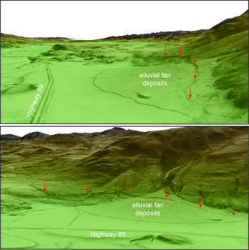
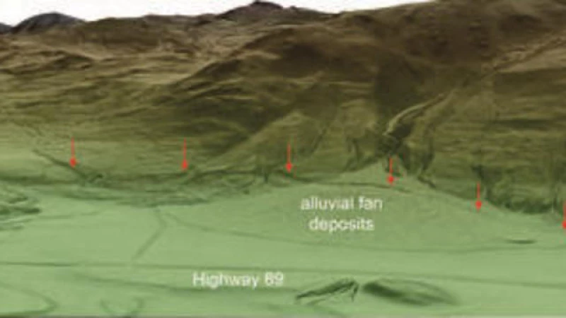
Faults and Landslides in Paradise Valley and Yellowstone
The recent data analysis has uncovered fault scarps near Gardiner, Montana, which are believed to be connected to the East Gallatin-Reese Creek fault system that extends into Yellowstone National Park. The findings have also revealed the presence of numerous large prehistoric landslides that have significantly shaped the landscape. These landslides were of such magnitude that they stretched downslope for miles and temporarily blocked a section of the Yellowstone River, resulting in the formation of a temporary lake at Yankee Jim Canyon.
The Montana Bureau of Mines and Geology is currently in the process of updating a statewide fault and landslide database with this new information pertaining to Paradise Valley and the northern entrance to Yellowstone. The aim is to enhance the assessment of potentially hazardous faults and landslides, which will contribute to future mitigation efforts at the county and state levels. Furthermore, the data will be utilized by the U.S. Geological Survey to improve the National Seismic Hazard Maps.