Severe Storm System Hits Gulf Coast States
A turbulent storm system barreled through Gulf Coast states on Wednesday, leaving major roads flooded and spawning possible tornadoes. Multiple severe thunderstorms — which can be breeding grounds for twisters in certain climates — were forecast with Mississippi, Louisiana and Alabama facing the highest risks of dangerous weather.
Meteorologists warned people to prepare for damaging, and potentially hurricane-force, winds, as well as several possible tornadoes. A few of those tornadoes could be powerful if they occur, they said.
"Widespread severe thunderstorms are expected today across parts of Louisiana, Mississippi, Alabama, and the Florida Panhandle. Tornadoes and widespread damaging winds are anticipated," the Storm Prediction Center said in an advisory posted around 6 a.m. EDT on Wednesday.
"All forms of severe weather will be possible, including tornadoes, some of which may be strong, and widespread damaging wind swaths with embedded significant severe gusts over 75 mph," the advisory said.
Hurricane-force winds must have sustained speeds of at least 74 miles per hour to fit that classification on the Saffir-Simpson Scale. Even at that baseline speed, wind gusts are considered "very dangerous" and capable of producing some damage to buildings and infrastructure, like roads and power lines, according to the National Hurricane Center.
The tracking site PowerOutage.us showed that around 150,000 energy customers were already without power on Wednesday morning. As of 8 a.m. ET, outages were mostly affecting Texas, Louisiana and Mississippi.
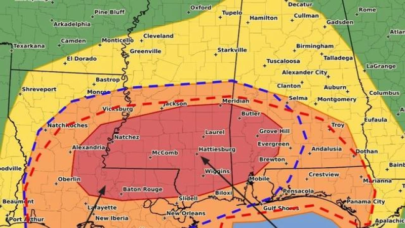
Some of the most significant weather hazards on Wednesday were expected in Louisiana and Mississippi.
More than 4 million people in parts of Louisiana and Mississippi were under a tornado watch that was expected to remain effective until 1 p.m. CDT, according to the National Weather Service. The watch area includes both states' capital cities, Baton Rouge and Jacksonville, and other major metropolitan centers like New Orleans. Meteorologists warned that places within the bounds of this advisory would likely see a few tornadoes and widespread wind gusts up to 80 miles per hour. Scattered hail, potentially as large as ping-pong balls, was also possible.
Severe Weather Threatens Gulf Coast States
The bout of severe weather was not expected to let up even after striking the Gulf Coast states during the first half of Wednesday. Come afternoon, meteorologists said the storm would probably cause "weak destabilization" over Alabama and the Florida Panhandle while moving east. That means an atmospheric environment that lends itself to severe wind gusts, and potentially even tornadoes, is set to develop in those regions.
Advertisement
Densely-populated parts of southeastern Texas were at risk of damaging thunderstorms as well as possible tornadoes as the storm system blew through Houston and its surrounding areas before continuing to track east. The weather service had issued a severe thunderstorm watch for more than 7 million people in that region overnight, warning that tornadoes were possible with destructive wind gusts potentially reaching 85 mph. That thunderstorm watch expired at 7 a.m. CDT, and trailed a a barrage of severe weather events in central Texas at the top of the week.
There were no tornadoes confirmed within the latest watch area on Wednesday morning, but the police chief in Port Arthur told KFDM that a suspected tornado had damaged homes and some public buildings in the area, including a church.
Meanwhile, the storm did bring torrential rain to broad sections of southeastern Texas, causing flooding that in some places prompted evacuations and highway closures. In Kirbyville, a city near the Louisiana border about 60 miles north of Port Arthur, officials said all major roads were inundated and shut down, with rescue efforts underway in the area.