USGS Warns 75% of U.S. Could Face Damaging Earthquakes
The United States Geological Survey has issued a warning stating that nearly 75% of the U.S. could potentially experience damaging earthquakes and intense ground shaking within the next century.
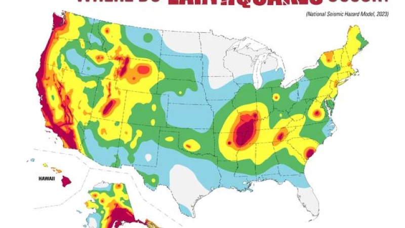
On Wednesday, the agency released new maps highlighting the areas that are most at risk. These maps were created by a team of over 50 scientists and engineers who utilized seismic studies, historical geological data, and the latest data-collection technologies.
Through their research, they were able to identify almost 500 additional fault lines that have the potential to produce damaging earthquakes.
Over the past 200 years, earthquakes exceeding magnitude 5 have occurred in 37 U.S. states, indicating a long history of seismic activity throughout the country, according to the USGS.
Which areas are most at risk?
The USGS clarified that they are not making predictions about specific earthquakes.
"No one can predict earthquakes," the agency stated. "However, by investigating faults and past quakes, scientists can better assess the likelihood of future earthquakes and how intense their shaking might be."
The new model reveals that the seismically active regions of California and Alaska are particularly at risk for earthquakes.
In 2019, the USGS highlighted the 1964 Great Alaska Earthquake and the Rat Islands Earthquake in Alaska the following year as two of the 10 worst earthquakes worldwide since 1900.
Earthquake Facts
There are approximately 10,000 earthquakes that occur each year in the Southern California area. However, most of these earthquakes are not felt by people. Only about 15-20 earthquakes have a magnitude greater than 4.0. (source)
In addition to Southern California, Hawaii also faces the potential for earthquakes due to recent volcanic eruptions and seismic unrest. A comprehensive assessment of Hawaii's earthquake risk has not been published since 1998. The last assessment for Alaska was published in 2007. (source)
Researchers have also found the possibility of more damaging earthquakes along the central and northeastern Atlantic Coastal corridor, including in Washington, D.C., Philadelphia, New York, and Boston. (source)
Implications of the Map
According to USGS geophysicist Mark Petersen, the new earthquake model is a "touchstone achievement for enhancing public safety." The model can provide critical information for architects, engineers, and policymakers, and can be helpful for the construction industry. (source)
For example, California is offering $3,000 grants for earthquake retrofitting. Civil engineer Joe Demers from Alpha Structural explained that during earthquakes, houses can literally fall off their foundations if the ground moves side-to-side. Such failures are frequently seen during earthquakes. (source)